 Live Music Archive
 Librivox Free Audio
 Metropolitan Museum
 Cleveland Museum of Art
 Internet Arcade
 Console Living Room
 Books to Borrow
 Open Library
 TV News
 Understanding 9/11
tv CNN Newsroom CNN October 28, 2012 5:00pm-6:00pm EDT
5:00 pm
a new -- delmarva peninsula, maybe other portions of the northeast like new york, connecticut, et cetera. the idea where that kind of cone is narrowing. >> every time the storm gets closer. you start to see the cone get smaller. because you would expect that, because the cone is a cone. so the farther you get away in time the error gets smaller and smaller. the center of the cone being
5:01 pm
somewhere north of cape may, atlantic city. but i just don't want you to focus on those cities. does it make that turn left in time? it didn't going left right now, and sometimes they wait. sometimes computers aren't perfe perfect, and why aren't they perfect? the atlantic ocean is a fast space, we don't have weather balloons out there. we have drop sons out of noaa weather radio. here it is, category 1, about an 80-mile-per-hour storm, right now as it makes landfall tomorrow night. and if there's any change to the forecast at all, i would say that's a little bit faster. the numbers bring in landfall the eye, but don't focus on 8:00, because a lot of the storm
5:02 pm
will be onshore, half of it will be onshore, even before the eye gets there, wherever it gets. you have to understand that things are going to start to go bad from here. this is how good it's going to get for the next 36 hours. no matter where with we are in here, this sides of it is so dangerous because the wins are coming in here. on up here into period of time. all the way here into tom's river and all of this has wind this way, the winds in washington, d.c. will be 55 or 60-mile-per-hour. but in the opposite direction. and it interacts with the next storm system, there's a low here, when those two actually combine, then we'll start to see the snow on this side, because it's cold over here, the snow will come in, and this will wrap up. for anymore, this will not feel
5:03 pm
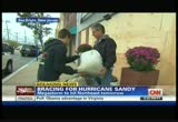
a hurricane. when it's a hurricane, it feels like it's 72, it's tropical. it's going to be cold, wet, and temperatures are going to be 45 or 50. this is going to be a brutal storm to be out in. >> you're saying nor'easter like? >> that's what this storm is going to turn into. this is like the perfect storm back in 1991. which caused billions and billions of dollars of damage, and it stayed out in the ocean. this storm does make landfall, it does make coastal surge. meantime a big warning coming from the president of the united states. he made a visit to fema headquarters and he said the resources are in place to deal with the storm and he expects fast response to any damage once that storm does hit. but he added, people really need to be prepared.
5:04 pm
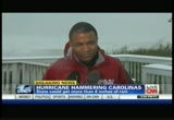
>> you need to take this very seriously, and follow the instructions of your state and local officials because they are going to be providing you with the best advise in terms of how to deal with this storm over the coming days. >> the president also held a conference call will governors and mayors that are in the storm's path. >> so emergency management officials, cnn's george how well is on the outer banks right now. you're feeling the effects of that storm in kill devil hills, george? >> we're also keeping in close contact with emergency management officials in their county. the latest from them. obviously the winds are strong out here. we're talking wind gusts from 40-mile-per-hour and i can tell
5:05 pm
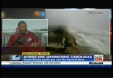
you the plus is in effect right now. these wind gusts if you're not careful will not be back. also when you look at what's happening out on the atlantic right now, very rough waters, they are keeping a close eye on that, on this side, as long as the winds continue to come from the west to the north, they're worried about storm surge on this side or as we speak on the south side, they are worried about that the winds are shifting, moving water around and then pushing it back out on to the sound, on the north, on the northern side of the outer banks, they're looking at three to five-foot storm surge. that's what they're watching out for along the outer banks and we also know that they cancelled -- ferry services have been cancelled in several different places, highway 12, the only way in and out of the outer banks, there is overwash in several
5:06 pm

places which means people are holed up until the storm passes through. >> appreciate that from kill devil hills, the rain is coming down pretty aggressively. so the delmarva peninsula which is parts of maryland, delaware, virginia. parts of ocean city, maryland are already under a mandatory evacuation order. it's picturesque because you've got some enormous surf picking up? >> you can see the waves picking up behind me. it's not even high tide, but that's what officials here are worried about, when that high tide affects sandy. the combination between those two means storm surge. the storm surge from hurricane sandy could rival hurricane gloria which destroyed and
5:07 pm

damaged the boardwalk here in ocean city. so that's something officials will be keeping an eye on. the mandatory -- residents have about a couple of hours to get out of town and the deadline remains in effect. and clearly this is a very rough area right now, already, we're feeling the winds, we're feeling the rain and there's also a voluntary evacuation for local lying areas as well. they're telling all visitors to get out of ocean city, they have closed down route 50 coming into ocean city already. so they're very prepared for this, but, wroum, talking to the mayor, he says that every storm is different and the personality is one that this storm is going to hover and linger for a long time and that's a real concern here. >> sandra endo thanks so much from oceans city. the hurricane coverage continues
5:08 pm

as the storm surges. it is going to be a very long night tonight for many people along the eastern seaboard. the worry now is what happens if power goes out in a very big way? it happened just a year ago, leaving millions in the dark.
5:09 pm

if we want to improve our schools... ... what should we invest in? maybe new buildings? what about updated equipment? they can help, but recent research shows... ... nothing transforms schools like investing in advanced teacher education. let's build a strong foundation. let's invest in our teachers so they can inspire our students. let's solve this.
5:10 pm

all right, hurricane sandy continues to barrel its way along the east coast, threatening the delmarva peninsula in particular which includes maryland, virginia, delaware, that could be hit especially hard by this storm that threatens to promote quite
5:11 pm
the storm surge. joining me on the phone, delaware governor, jack mar quell, i understand that you are under the boardwalk at rohoba's beach, what is it like there? >> the center of it is still hours away, it's rough even like it is at the height of the storm. >> we are concerned and the message is if you live in an evacuation area, the time to live the is now. the problem is if you stay, you could very well be cut off. you put yourself in harm's way, you could put others in harm's way as well. so we're really recommending
5:12 pm
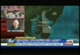
people get out. so in many cases you have hoes -- >> we haven't -- for people who want to leave -- duey and bethany beach that one is closed so there are other evacuation routes for people, but now is really the time. >> we have already seen some flooding, but still quite pertinent, right? >> we're seeing more flooding than we normally would. we have opened several shelters across the state. providing that and they're already starting to get people there which is good. businesses in the evacuation area have to close by 6:00 p.m. tonight, but bottom line, again, people in the evacuation areas, it's time to get out.
5:13 pm

>> and what kinds of pieces -- >> i can't quite here you but there are some essential businesses that are staying open, but for the most part the businesses in the evacuation area are closing and people are leaving. >> and given that it's fall, it's kind of your offpeak season. governor jack mar kell, appreciate your time and stay safe. people along the east coast did brace for the hurricane surge, but the utility companies are trying to get ready. last year millions lost power and preparations are under way just in days there's a repeat. in that time there've been some good days. and some difficult ones. but, through it all, we've persevered, supporting some of the biggest ideas in modern history. so why should our anniversary matter to you?
5:14 pm

because for 200 years, we've been helping ideas move from ambition to achievement. and the next great idea could be yours. ♪

5:16 pm

as the east coast braces for hurricane sandy, one of the biggest concerns is keeping the power on for millions of people in the path of that storm. david owens is the executive vice president of the executive electrical institute. good to see you. >> preparations have become a
5:17 pm
collaborative effort with this storm, but to what extent? >> we have what we call a mutual assistance program whereby you tillity crews throughout the united states work together so when one utility has a difficulty, other utilities pitch in and send crews. if you for example compared it to hurricane ike, when we had over 50,000 workers that were there to restore power, we're going to have far more than that, we have people come in as far west as california and in fact we are flying in personnel from those regions, because we think that this storm has great severity and we're very, very concerned. we have not probably experienced anything like this. they say this is a storm for 100 years and we're certainly prepared to deal with it in that context? >> i also understand from canada and even mexico. >> from canada, from mexico,
5:18 pm

from texas. we mobilize together as an industry in order to bring electric confidence back to our customers. this partnership has existed since 1955 and we're dedicated to the safety of our customers and restoring power to them. >> and this is a major undertaking because of what we just saw this past summer, the people in the mid-atlantic area were without power for a very long time because of a storm and it was just last year with hurricane irene that brought a lot of power outages for a very lengthy time to the state of connecticut. >> that's right, i would contrast this storm from the deratio we experienced this summer, where it same upon us all at once, we didn't have the time to stage our crews. this time we have several days warning, we're staging our crews, but again, this is going
5:19 pm

to be a very, very severe storm. mr. owens, meteorologist chad myers has a question for you. >> this is going to be one of those big storms, it's going to be windy for a long time and people are going to lose power at the beginning and are going to be very impatient in the beginning, and you won't put crews out there until what purpose? you're obviously not going to put men in bucks at 60? >> yes, we'll wait until the wind dies down. so obviously, we're only going to have those crews seek to restore service. you first have to assess the damage and we believe that there will be substantial physical destruction of our infrastructure, we're going to have to assess that damage, we're going to have to bring energy back to our essential facilities facilities, our transmission lines, we have to bring back our critical loads,
5:20 pm

our hospitals, our police, our fire departments, our main arteries where people can shop, can get food and other essentials. so we have experienced storms in the past, but this is going to be a storm of tremendous punch, of tremendous magnitude. >> when you talk about assessing the damage, you're talking about assessment that doesn't take just hours, sometimes that takes days as well. >> it certainly does. >> david owens, executive vice president of the electrical institute. thank you for taking time to come on. >> this is likely to be a historic storm. what exactly does that mean to folks up and down the east coast? we'll update you after this. you've been busy for a dead man. after you jumped ship in bangkok, i thought i'd lost you. surfing is my life now. but who's going to ....
5:21 pm

tell the world that priceline has even faster, easier ways to save you money. . . on hotels, flights & cars? you still have it. i'll always have it. so this is it? we'll see where the waves take me. sayonara, brah! how they'll live tomorrow. for more than 116 years, ameriprise financial has worked for their clients' futures. helping millions of americans retire on their terms. when they want. where they want. doing what they want. ameriprise. the strength of a leader in retirement planning. the heart of 10,000 advisors working with you one-to-one. together for your future. ♪
5:22 pm

the silverado's powertrain warranty is 40,000 miles more than ford. and this workhorse gives you the power of a v8 with the highway fuel economy of a v6. incredible! right? an amazing test drive. i agree. [ male announcer ] it's chevy truck month. just announced additional $750 bonus cash on a 2012 chevy silverado all-star. trade up to get a total value of $8,750. bonus cash ends october 31st.
5:23 pm

all right, welcome back, amtrak northeast service cancelled tonight at 7:00 p.m. eastern time. then in new york, mandatory evacuations are underway in zone a areas, including staten island and the rock aways. let's bring in meteorologist
5:24 pm
chad myers to talk about zone a, a lot of folks maybe don't even know they live in zone a, mayor bloomberg making it very serious, saying we're cutting off hot water and heat in those areas. there's the jfk then we start battery park city, all the way up manhattan and up the hudson to the east river here. we're talking just up the east river and downa little farther is the red book, these are all the low-lying areas that will be inundated with the expected
5:25 pm

surge and then across staten island. watch your stuff there, and there, even with zone a. we're only showing thatborouthat bur bourough threw, there's going to be evacuations from new jersey as well. we just don't have them plotted on there. if you know that you live less than 10 feet above sea level in the new york metro area, connecticut, long island, new york city, hoboken, you need us to get out of there. it's just that simple. because that's how high the water is going to be. >> that staten island ferry stops at 8:00. so you better have a contingency plan. >> people are going to be stranded in places that they don't want to be. but you wanted to be on the 8:00 train to new york,itis not going to be there for you. the transportation night marry that continues. then you're going to be in
5:26 pm
places, or you're going to be stuck in places where you don't know the topography. all these people, are going to be trance planted in places they don't want to be, they think they're going to be there, and they're starting to hunker down in the next 24 hours. >> we're talking about the storm surge in large part that are threatening these low-lying areas. >> and the surge is going to start into cape may as the water runs up the river. but you start and you take a look at the right side of where the eye makes landfall and you're going to see anywhere from wild wood, northward, all the way up to sea bury, those barrier islands, all those islands are going to be overwashed with water, if you're not on stilts, some of those homes are going to go away. i think it was really telling, i wasn't here for the interview, but when you talked to the mayor of rohoboth?
5:27 pm
>> yes, it was the mayor of rohoboth. >> i wanted to ask him, was it storm surge from the ocean, was it rain water frolooding? but it doesn't matter, you're in trouble if you're there. there's so many parts to this. i want to talk to you about what happens in boston, what happens in connecticut, what happens in long island, what happens along long island sound. every place will be different. what happens in wilkesbury is not going to be the same as what happens in boston. it's going to be different debah pending on how warm it is on one side and how cold it is on the other side. >> your local national weather service office will be able to tell you more about your local area than i can. i can't tell you the overall scope. i can try to do that in five
5:28 pm

minutes. i can't go state by state, city by city, it would just take too long. and your local authorities know everything about where you live and the local conditions are going to be. >> it's really going to be a transportation nightmare as well. you talk about the storm surge and it also means that railways are not going to be working like people want them to. roadways, we fwoe there's an awful lot of flight cancellations as well. you see us bank on busier highways. on once empty fields. everyday you see all the ways all of us at us bank are helping grow our economy. lending more so companies and communities can expand, grow stronger and get back to work. everyday you see all of us serving you, around the country, around the corner. us bank.
5:29 pm

♪ atmix of energies.ve the world needs a broader that's why we're supplying natural gas to generate cleaner electricity... that has around 50% fewer co2 emissions than coal. and it's also why, with our partner in brazil, shell is producing ethanol
5:30 pm

- a biofuel made from renewable sugarcane. >>a minute, mom! let's broaden the world's energy mix. let's go.
5:31 pm

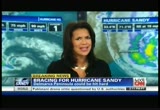
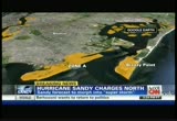
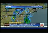
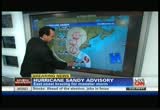
all right, we're keeping a close eye on hurricane sandy as it charges up the east coast. this is the latest word from the
5:32 pm
national hurricane center. sandy is churning out in the atlantic. and we believe it's also about 530 miles according to our chad myers from the new york city area. as it makes its way from the north atlantic to the northeast. that's when it will be colliding with a cold front, virginia, connecticut, sometime tomorrow night and thousands of people in the low-lying areas are already evacuating from north carolina all the way up to maine. stocking up on supplies, for widespread power outages as well that could last days. so new york, already updates now that the subway and commuter train service has been suspended beginning tonight at 7:00, mandatory evacuations of low-lying areas are in place. the stock exchange will remain open, but only electronic trades, nothing in person. we want to update you because i actually think that's not
5:33 pm
correct, that's going to be closed as far as we know. broadway performances have also been cancelled. then on to new jersey where a state of emergency is already underway, mandatory evacuations are in place in parts of the state. all state offices are closed tomorrow and the new jersey transit is shutting down at 4:00. and in virginia, we understand that schools are being transferred in arlington. the state of emergency has been declared there. voluntary evacuations are underway in low-lying areas, except mandatory evacuations are in place for places like ocean city. and we also understand that that early voting that had kicked in in virginia and maryland today, well in maryland, no early voting for the general election taking place tomorrow. and then washington, d.c., public schools are closed tomorrow, sandbags are being
5:34 pm
distributed to residents and then pennsylvania, it too is looking at this storm and putting precautionary measures in place. disaster area, emergency disaster declaration has been put in place for pennsylvania and massachusetts. a state of emergency has been declared and we heard from governor duvall patrick that am track service in the northeast will be suspended in the northeast starting at 7:00 p.m. this evening. so lots of precautions being put in place all listening the mid-atlantic, as well as the northeast. so planes, trains, busses all grounded for a good amount of time. josh levs is in the hurricane center to bring us up to today. >> it keeps on growing, let me set the scene for you, i'm at the cnn hurricane desk and what you're seeing around me, you're
5:35 pm

seeing people that are from every state, every area that could be impacted as this storm approaches land. before we go into transportation, fred, this is really interesting to me, the u.s. nuclear regulatory commission is now sending inspectors to all the nuclear power stations that are in the path of sandy. any time i say nuclear on the air, that doesn't mean that means any kind of disaster, they're sending inspectors to be at these facilities to act quickly if the worst were to happen. so to the commission's saying that. this is going to impact not just all of you who are in the path of the storm itself. but i will tell you the latest we have gotten now that comes in from the southeastern pennsylvania transportation authority, they are announcing that they are shutting down -- the entire transportation
5:36 pm
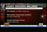
system. now i want to give you some numbers, i want you to understand how many millions of people we're talking about. it's going to help you ups how many millions of people we're talking about being impacted. the new york city subway system alone has 4.3 million riders every day. and that's been closed. the metropolitan transportation authority, the system in new york and new jersey has about 8.5 million riders a day. that's closed. and i have confirmed with am track. amtrak does say that for tonight and at least through tomorrow, they're closing the northeast corridor and that is $750,000 riders a day. i want you to see what's happening with planes, all over the country, a a lot of planes are being shut down. american airlines at least 1,500 flights cancelled. delta and us airways, a lot of
5:37 pm
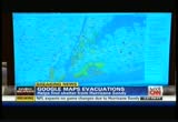
lights being cancelled. while aisle talking about cnn.com, i want to show you something that just popped up, google is now working with new york. this is an interactive map that shows evacuation areas in new york. watch what happens if i -- if you're in the new york city city, you need an evacuation center to go to, you -- watch what happens when i click storm surge probability, yowser. obviously we're hearing a lot of great information from the hurricane center as well as chad myers. if you're in a position to take photos or videos safety. you can contribute to our i-report coverage of what's going on. i'm not going to show any
5:38 pm

i-reports of anybody who violated a mandatory evacuation order. if you're in a position to take images safely, contribute to our i-report coverage. we're seei ining different part the country that are being impacted all right. i'm struck by that one because you see a family that was apparently all set for halloween. in the meantime, keep it with us on cnn.com. i have also got a lot going on with you very often. and fred, we will be back with you for a little bit even for more breaking details. >> we'll be right back for the mass transit shutdown in new york city, right after this as well.
5:39 pm

when you take a closer look... ...at the best schools in the world... ...you see they all have something very interesting in common. they have teachers... ...with a deeper knowledge of their subjects. as a result, their students achieve at a higher level. let's develop more stars in education. let's invest in our teachers... ...so they can inspire our students.

5:41 pm

to meet the needs of my growing business. but how am i going to fund it? and i have to find a way to manage my cash flow better. [ female announcer ] our wells fargo bankers are here to listen, offer guidance and provide you with options tailored to your business. we've loaned more money to small businesses than any other bank for ten years running. so come talk to us to see how we can help. wells fargo. together we'll go far.
5:42 pm

all right, desperate times calling for desperate measures, that's why officials in new york city are responding to hurricane warnings. so mr. lotto, i'm talking about bus service that's going to be suspended starting at 9:00 p.m., and subways that are going to be shut down at 7:00 p.m., is that right? >> 7:00 p.m. tonight, we're going to be begin the shut down of the subway system, no guarantee that you'll be able to get a ride on the subway past 7:00 p.m. tonight, but we're going to go all the way through to 3:00 in the morning when it's going to be all the way shut down. >> why is it and how did you come about these hours as the best recommendsed time to kind of stop mta?
5:43 pm

>> what's really important to understand in this decision to do it now is not necessarily where the hurricane is right now, we're pretty confident that we're going to be having a water surge as well as high winds. what we really needed to do is to make sure that all of our pape were safe, all of our passengers were safe. but what's more important, if we had surface on monday morning and bring everything into new york, we would not be able to get them home. 8.5 million people are on the mta every single day and you can't have that many people stranded in new york. >> and how concerned are you about all of those evacuations, zone a, mandatory evacuation, we heard that from the mayor just a few hours ago, how concerned are you that -- >> i'm not concerned. we're working very, very closely with the city in the evacuation process, right now, that's only about 325,000 people. believe it or not for the mta,
5:44 pm

we cannot handle that level, as long as the folks are prepared to move, we're prepared to help in that process. >> 325,000 people, nothing compared to the 8.5 million people who travel on mta every day. so all states along the east coast particularly mid-atlantic up to the northeast taking the threat of hurricane sandy very seriously, the governors and mayors of so many of those states are keeping everything posted as best they can on preparations, evacuations, closures. we're talking about a very concentrateded metropolitan area from as far south as north carolina all the way up to maine. >> and we heard from the connecticut governor and it seems like the worst-case scenar scenario, there was little if any good news that came out of this press conference, governor malloy took it a step further,
5:45 pm

he said historic flooding and possibly some major damage there as a result of hurricane sandy, take a listen. >> we are talking about extensive flooding, maybe the worst that we have seen in 70 years. the most significant threat we're facing now, right now is the fact that we will be experiencing four high tides from the time the storm starts until it ends. with the worse one being late tomorrow night. the amount of water the storm is expected to push into long island sound is far more than the sound the shoreline can handle. the numbers that we are starting to look at right now suggest in a worst-case scenario that we will see water surges unlike connecticut has seen in more than 70ers referencing the 1938 storm. >> he brings up that 1938 storm which causes hundreds of deaths and was a very big problem there in connecticut. but, fred, the problem is that we're dealing with residents who
5:46 pm

have gone through this before, fatigue's there, people who have been in the eye of the storm and there were similar predictions there, there was wind, there was storm surge, so we're hearing from governors more aggressive-new jersey transit will begin gradual testimony wide shut down of all bus, light rating and that starts at 4:00 p.m., so you see all afters being used here to get the news out to residents. >> and mayor cory booker, he's a very big tweeter. he's also up front with the audience and -- he said the biggest concern there for him is the people that aren't prepared. >> the biggest thing that we're concerned about right now is individuals not taking this storm seriously enough.
5:47 pm

the human error that often comes from a lack of preparation or a lack of sobered understanding of what is going to happen to the state of new jersey. and many of the chririses we ha had before were because of people not responding to the crisis. >> in new york, they're actually sending messages to residents phones. we talked to a resident who got a message on her iphone. also a little while ago, free web access from "the wall street journal" and the "new york times." >> so the access to information, it's all there. weather conditions indeed are deteriorating along the east coast, we'll bring you the very latest on hurricane sandy, where it is and where it might be


5:50 pm

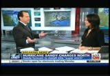
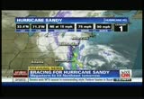
all right. more on hurricane sandy now. we are talking about it being a couple hundred miles off the coast of north carolina, about
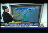
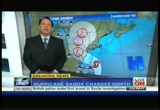
5:51 pm
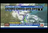
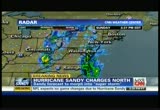
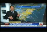
500 miles off new york city's coast. let's go to meteorologist chad myers. all the cities from north carolina to maine are very concerned about what sandy might bring. storm surge is a big concern. >> of course. because the water is so heavy. even standing out at the beach and getting knocked down by a three-foot wave when having fun on the beach is nothing like what you'll feel with the weight of this water where the water is 12 feet or higher. plus, we have full moon. the full moon will make the normal tides a couple of feet higher than normal or then a low tide. so that's good for the low because that will make the water go down when we have the low tide, at least a little bit, and then it is bad for the high tide because then you have the high tide added to the storm surge. there's the storm right now and you made reference to kill devil hills, that's 300 miles from there, maybe less. and 500 miles from new york city. the forecast is for it to do
5:52 pm
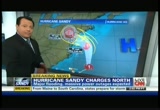
something like that and then like that. but the cone is still here and here. we always have to talk about the cone. nothing is in stone until it makes landfall. it is raining in annapolis, d.c. and bowie. all the areas here in eastern north carolina. the storm anywhere from about long branch all the way down to the border between the delmarva there that's delaware and to virginia. and the cone gets smaller. notice how small the cone is when it is very close to where it is. and the cone gets bigger as it moves away. and the problem, another problem is there's another low pressure system swinging in from the southwest here that will grab this thing and spin it around. it will almost stall it for a couple of days. it moves it a little bit from here to here, but if you think about rain and this shield, and it rains for 48 hours there, we are going to get flooding. we are also going to keep the wind going 50 or 60 miles per hour. and then you're going to see the trees get knocked down because, well, the ground is wet. all of a sudden the trees are
5:53 pm
blowing 50 and the trees will come down and the power lines. millions of trees and power lines down with it. there's a couple forecast models still up for new york city. a couple still down here, that's wilmington, that's rehobeth. and right through here, most of the mass of them across new jersey. it isn't that it is going to miss something, it is going to hit something. and it is so big that if you think of the center, like you think of a cat 2, 3, or 4 in the center, that's not the issue. this storm is 500 miles on both sides of the storm with winds over tropical storm force. the winds will gust to 60 in maine. they will gust to 60 in washington, d.c. 80 here across parts of new jersey and even through here because of the big high pressure back here and the low will be here, the wind is going to howl through detroit. it will howl down lake michigan and you could see lake-effect snow there, but an awful lot of
5:54 pm
snow through parts of west virginia. some of the new computer models are saying 60 inches of snow. and now blizzard warnings just posted. >> wow, given you talk about the circumference and the width of the storm, no matter what with the whole spaghetti map, one place may not get a direct hit but it will still get the impact of the storm because it is so wide and seemingly so monstrous. >> there's nobody from maine to virginia that's not going to feel something. and it is just a matter of where you are into the center, whether your winds will be east, west, south or north. and they will be blowing hard for days and the power is going to be out for days in many spots. >> my goodness. chad myers, thank you so much. we'll keep you posted throughout the evening. much more after this. at legalzoom, we've created a better place to turn for your legal matters. maybe you want to incorporate a business you'd like to start. or protect your family with a will or living trust. legalzoom makes it easy with step-by-step help when completing your personalized document --
5:55 pm

or you can even access an attorney to guide you along. with an "a" rating from the better business bureau legalzoom helps you get personalized and affordable legal protection. in most states, a legal plan attorney is available with every personalized document to answer any questions. get started at legalzoom.com today. and now you're protected. boring. boring. [ jack ] after lauren broke up with me, i went to the citi private pass page and decided to be...not boring. that's how i met marilyn... giada... really good. yes! [ jack ] ...and alicia. ♪ this girl is on fire [ male announcer ] use any citi® card to get the benefits of private pass. more concerts. more events. more experiences. [ jack ] hey, who's boring now? [ male announcer ] get more access with a citi card.
5:56 pm

[ crowd cheering, mouse clicks ] [ male announcer ] get more access with a citi card. one is for a clean, wedomestic energy future that puts us in control. our abundant natural gas is already saving us money, producing cleaner electricity, putting us to work here in america and supporting wind and solar. though all energy development comes with some risk, we're committed to safely and responsibly producing natural gas. it's not a dream. america's natural gas... putting us in control of our energy future, now. and his new boss told him two things -- cook what you love, and save your money. joe doesn't know it yet, but he'll work his way up from busser to waiter to chef before opening a restaurant specializing in fish and game from the great northwest. he'll start investing early, he'll find some good people to help guide him, and he'll set money aside from his first day of work to his last, which isn't rocket science. it's just common sense. from td ameritrade.
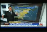
5:57 pm

all right. we continue to watch hurricane sandy. it's roughly about 200 miles off the coast of north carolina, roughly 500 miles from new york city. but places from north carolina all the way up to maine are bracing. in fact, we have a few updates. d.c., federal offices will be closed to the public tomorrow. we already know that washington, d.c., public schools are closed. more on hurricane sandy straight ahead. we know that mass transit from buses in new york will be closed or will shut down starting at 9:00 this evening and 7:00 for the subway system.
5:58 pm

that's impacting a bunch of people. much more ahead on "newsroom" with don lemon. this is a monster storm that could take many directions stat. states and cities are taking different directions and you can't be complacent. >> it is almost too late. you have been here since 2:00 on the snare. >> yeah, and you have a long haul for the evening. things will be changing on the dime, we know that. >> we have a lot of people out there. thank you, fred. have a great evening. >> thank you so much. >> thank you everyone for joining us. it's the top of the hour. i'm don lemon here in the newsroom. two words to dominate the news. about to make life miserable for millions of people, i'm talking about hurricane sandy. look at that sideways rain and a wall of wind. the outer banks of north
5:59 pm

carolina are just starting to feel the first punch of this hurricane. now this storm is huge and is headed ashore. there are questions for you, where exactly will it make landfall and will the people who did not evacuate be prepared to handle it? president obama got a full briefing at fema headquarters today. look at it. >> this is a serious and big storm. and my first message is to all people across the eastern seaboard, the midatlantic going north, that you need to take this very seriously. >> the president is saying to take it seriously, you should. the severe weather team is in place with reporters all along the shore and ted myers here with me. sandra endo is coming to you in a minute and chad myers coming to you in main. but first we want to update you to the outer banks where george howell is on the bank in kill vi
142 Views
IN COLLECTIONS
CNN Television Archive
  Television Archive News Search Service
Uploaded by TV Archive on
